SONS OF DEWITT COLONY TEXAS Empresario Contracts in the Colonization of Texas 1825-1834 For more biographical information, Search Handbook of Texas Online
The following is a modification from Readings in Texas History by Eugene Barker abstracted from articles in The Southwestern Historical Quarterly, XXXI, 295-324, XXXII by Mary Virginia Henderson. It describes how and by whom the colonization laws of Coahuila and Texas were implemented. The contracts of Moses and Stephen Austin, Green DeWitt, De Le�n, the Irish Empresarios and Haden Edwards are covered in more detail elsewhere. Mexico's preparation for the colonization of Texas---The establishment of an independent government in Mexico marked the beginning of a new era in the history of Texas, an era in which the suspicion and hostility of Spain toward all foreigners, and especially all citizens of the United States, was to be superseded by an invitation to the world to build homes within Mexico's vast wildernesses. When Spain controlled the territory, foreigners found without passports were thrown into prison where they might remain many weary years. With the establishment of Mexican authority over Texas, the attitude toward foreigners was very different. As expressed in the colonization law of the State of Coahuila and Texas, it was "the state invites and calls them." Many answered the call, some as empresarios and others as colonists. The purpose of this paper is to give, wherever possible, a brief account of the work done by the minor empresarios of the period from 1825 to 1834. The better known empresarios, Stephen F. Austin, Green DeWitt and Haden Edwards, will not be included. To understand the work of the empresarios, it will be necessary to examine some of the provisions of the colonization laws of Mexico and of the State of Coahuila and Texas. Mexico passed her first colonization law in January, 1823, while Iturbide was emperor. With his overthrow in March, 1823, and the repeal of the colonization law Of 1823, it was then necessary for the Mexican Republic to formulate its colonization policy. On August 18, 1824, the central government passed the national colonization law. This laid down a few general regulations with reference to colonization within the nation, but left the undertaking largely to the states. In the first place each state was to pass a colonization law for the settlement of the unoccupied territory within its limits. However, only the federal government could grant permission to establish settlements within twenty leagues of the boundary of any foreign nation or within ten leagues of the coast. Other provisions were that no person could hold more than eleven leagues of land. A preference was to be given in the distribution of land to Mexican citizens, but no other discriminations were to be shown except for individual merit or services rendered the country or under equal circumstances to the person who lived in the place where the land was located. It was not possible for any person who acquired land by virtue of the law of August 18, 1824, to hold that land if he lived outside of the Mexican Republic. An especially significant provision of the law occurred in Article 7: Until after the year 1840, the general congress shall not prohibit the entrance of any foreigner as a colonist, unless imperious circumstances should require it with respect to the individuals of a particular nation. Mexico seemed to realize that "imperious circumstances" might arise. If they should, that is, if the immigrants from any particular nation seemed to be too numerous, or lacking in loyalty to Mexico, she could forbid their further entrance with ease. The same law which gave immigrants permission to enter would guarantee to her the right to close her gates to them whenever she considered it expedient. The colonist at the time of his entrance into Texas seemed so eager to try his fortune in the state, that he scarcely noticed, and perhaps did not notice at all, that provision of the law. However, when Mexico took advantage of the provision and passed the law of April 6, 1830, by which she forbade the further entrance of citizens of the United States into Texas, the colonists then protested vigorously. Some declared Mexico had no right to pass the law. Mexico had, though, made her position secure when she included Article 7 in the national colonization law. The significance of the law of April 6, 1830 will be seen later in the history of the colonization contracts. In accordance with the national decree of August 18, 1824, the Legislature of Coahuila and Texas on March 24, 1825 passed its colonization law. As has been said, the state invited foreigners to make their homes on its unoccupied lands. All colonists bad to "prove their Christianity, morality, and good habits by a certificate from the authorities where they formerly resided." No commissioner could issue titles to land for a colonist until he received a written statement from the empresario approving the petition of the settler for land and thereby declaring his character satisfactory. The empresario, in most cases, accepted the certificate from the authorities of the immigrant's past place of residence as satisfactory evidence of moral character. The state colonization law granted to each married man who wanted to farm one labor, an equivalent of 177 acres. If he also desired to raise cattle, he could obtain twenty-four labors of pasture land or 4,251 acres. The total of farming and pastureland made one sitio or league, consisting of 4,428 acres. An unmarried man received one-fourth of this amount. If the colonist's occupation or capital was such that it would benefit the colony, he could obtain additional land. The new settler was required within six years to pay a nominal sum to the state for his land. For each sitio of pastureland he paid $30; for each labor of unirrigable land $2.50; and for each labor which was irrigable he paid $3.50. The government required no part of it to be paid until the end of four years. At the close of the fourth year one-third of the amount was due; at the end of the fifth year, another third; and when the sixth year closed, the last payment was to be made to the state. To acquire a title to his land the colonist had to occupy or cultivate it. The law extended the empresario or contractor system, which had been provided for in the national law. Each empresario made an agreement with the state to introduce a certain number of families within six years. He received a definite area in which to locate his immigrants. Often his territory was spoken of as his grant. The use of the term was misleading. It led people unacquainted with the colonization laws to believe that all the land within the grant belonged to the empresario to dispose of as he desired. In reality the land was only allotted to the empresario to settle with colonists. At first he did not own one acre of it. Although he would eventually receive a premium in land for each one hundred families introduced, no premium was due until he had located at least a hundred families. The premium consisted of five leagues and five labors for each hundred families settled on his grant. No empresario was permitted to receive a premium for more than eight hundred families. Since, however, the maximum premium an empresario might obtain was more than the eleven league limit fixed by the federal law, he had to alienate the excess within twelve years. The state law repeated the restriction of the federal law with reference to grants within twenty leagues of the boundary of any foreign nation or within ten leagues of the coast. It was under the national law of August 18, 1824, and the state law of March 24, 1825, that most of the empresario contracts were made for the colonization of Texas. Even before the federal colonization law was passed, there were men in Mexico City who were trying to obtain empresario contracts. Among them were Haden Edwards, Green DeWitt, Frost Thorn, and General James Wilkinson. Stephen F. Austin was also there, but for the purpose of having his father's grant confirmed. With the promulgation of the national law making it necessary for each state to pass a colonization law, those who were endeavoring to obtain contracts transferred their attention to Saltillo, the capital of Coahuila and Texas. In less than a month after the passage of the state law and in one day's time, the Governor of Coahuila and Texas contracted for the introduction of 2,400 families. On April 15, 1825, Haden Edwards and Robert Leftwich each contracted to introduce 800 families. On the same day Green DeWitt and Frost Thorn each made contracts for 400 families. Other contracts issued under the state law of 1825 are listed below with empresarios that established some families permanently on their grants shown in red. As far as records exist, the others failed to settle any families within their contract. By 1832 Mexico, which had grown suspicious of the Anglo-Americans and had begun to doubt the wisdom of the policy of colonization, saw its opportunity and attempted to seize it. Some of the empresario contracts had expired and others were expiring without the empresario's having fulfilled them; the vacant land was therefore back in the possession of the government. Coahuila and Texas could then dispose of it as its Congress saw fit. The legislature passed a law, April 28, 1832, offering special protection and aid to Mexicans who should agree to settle on vacant lands in Texas, and making inducements to empresarios contracting to colonize with Mexicans or foreigners not excluded by the law of April 6, 1830. By May 1 the state had made a contract with Juan Vicente Campos, the agent for a Mexican company, composed of Mariano Dominguez, Fortunato Soto, Juan Ramon Mila de la Rosa, and John Charles Beales to introduce 450 families; and on October 9, 1832, a contract was made with John Charles Beales and James Grant to introduce 800 families. Although Beales and Royuela's grant was the last under the law of March 24, 1825, the grant to Beales and Grant, being under the law of April 28, 1832, seems to have been the last made by the government of Coahuila and Texas according to the records at my disposal. If it had been possible to settle the number of families designated by the contracts, Texas would soon have boasted of a fairly numerous population. Besides the Austin grants, contracts approved in 1825 called for 2,641 families, in 1826 for 1700, in 1827 for 100, in 1828 for 800, in 1829 for 850, in 1830 for 800, in 1831 for 600, and in 1832 for 1,450. However, Texas did not increase in population, as a result of the colonization laws, as rapidly as might have been expected from the long array of contracts. Stephen F. Austin, who fulfilled several of his contracts, was the outstandingly successful empresario. Next to Austin in point of success was Green DeWitt. Others, as De Le�n, McMullen and McGloin, Robertson (who was the success of the Nashville Company), Milam, Hewetson and Power, and Zavala, Burnet and Vehlein (the Galveston Bay and Texas Land Company) did actually establish some colonists permanently on their grants. There were still others who either made no permanent settlements of colonists or who made no attempt to fulfill their contracts, as Wavell, Wilson, Wilson and Exeter, Woodbury, Cameron, Dominguez, Filisola, Padilla and Chambers, Thorn, Purnell and Lovell, Beales and Royuela, and Campos for the Mexican Company, and Beales and Grant. The provisions of the contracts practically all followed the same general outline. At the beginning of the contract the government stated that it admitted the petitioner's proposal to colonize vacant lands "in so far as it is conformable with the colonization laws." The provisions were then stated, the usual ones being as follows: 1. A statement of the boundaries of the proposed colony. 2. That the empresario should respect the possession of lands which were already occupied under legal title. 3. That the empresario should introduce the required number of families within six years or forfeit all rights and privileges granted to him by the law of March 24, 1825. 4. That the families were to be of the Catholic religion and of good moral character. 5. That the introduction of criminals was not allowed. If any should appear, they were to be ejected. 6. That the empresario should organize a national militia force and command it unless otherwise ordered. 7. That when the empresario had introduced one hundred families, he should notify the government in order that a commissioner might be sent to give the colonists possession of the land. 8. That all official communications with the government and all public acts and documents were to be written in Spanish. 9. Contracts made after April 6, 1830 contained the restriction that no immigrants from adjoining countries were to be allowed to settle. In several of the contracts appeared the admonition to the empresario to prevent all persons from bartering arms and ammunition with the Indians for horses and mules. Two groups of empresarios---The empresarios, the guiding spirits in the colonization of Texas, fell into two groups. The first of the groups consisted of men who through their own efforts, or the efforts of others, really accomplished something toward the settlement of their grants. They were not notably successful, as was Stephen F. Austin; but they were instrumental in locating a number of families permanently, and thereby aided in bringing civilization to Texas. Such men were Burnet, Zavala, Vehlein, Robertson of the Nashville Company, Milam, McMullen, McGloin, Hewetson, Power, and De Le�n. The second group included the ernpresarios who obtained contracts from the government, but who, either because of the lack of initiative and judgment, or because of shortage of capital, were unable to make any contribution to the settlement of the state. Efforts toward colonization by the first group were in three distinct sections of Texas. The grants of Burnet, Zavala, and Vehlein formed a compact area in East Texas between the San Jacinto and Sabine rivers. Robertson's and Milam's grants lay in central Texas northwest of Austin's colonies. On the coast to the south were De Le�n's and Power and Hewetson's grants; adjoining Power and Hewetson and to the northwest lay McMullen and McGloin's grant. Boundaries of the Empresario Grants Click on
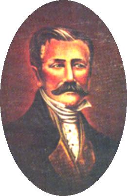
In April, 1824, Martin De Le�n, a native ranchman of the state of Tamaulipas, decided he wo9uld like to move with his herds to the grassy lands of Texas. Just the year before while driving mules from his ranch to the market at New Orleans, he had passed through the southern part of the state; and it was then that the tall grass of South Texas made its appeal to the ranchman. On April 8, 1824, he petitioned the Provincial Delegation of San Fernando de Bexar, which was the government of Texas, for permission to establish himself and forty-one families at a point on the lower Guadalupe where he would found a town to be called Nuestra Senora de Guadalupe de Jesus Victoria. As this was before the passage of the national colonization law, the Provincial Delegation of San Fernando de Bexar was the authority which granted De Le�n his petition. De Le�n's colony was also different from the other minor empresario colonies in that his contract did not specify a definite number of families to be introduced, nor fix a time limit, nor did it establish boundaries for the colony. When he had located his group on the lands desired, he was to notify the Provincial Delegation in order that the lands might be designated for the location of the town, and also that each individual might be put in possession of land for his house and field. The contract exempted the colony from duties for seven years on everything except tobacco and from excises, tithes and first fruits for ten years. By October, 1824, De Le�n and twelve of the forty-one families promised had established themselves with their droves of horses and cattle on the Guadalupe River about one-fourth of a league from the Atascocito Road. The other twenty-nine Mexican families expected to follow De Le�n to Texas, but were prevented during that year because of the drought, which destroyed the pasture on the road, and later in the same year because of the excessive rains. Shortly after the arrival of De Le�n, he was joined by sixteen Anglo-American families. By the following spring the grassy wilderness had become the scene of a flourishing little settlement; the fields had been cleared and planted and, among other improvements, provision had been made for the watering of the herds of cattle. Upon this scene of activity appeared a new empresario, who claimed their lands. This was Green DeWitt, who had on April 15, 1825, received a contract from the legislature of Coahuila and Texas for a grant of land which included De Le�n's settlement. DeWitt was as surprised to find the bustling scene of activity in the center of his grant as were De Le�n and his colonists to learn that their lands had been incorporated in another grant. Since De Le�n had failed to notify the government of his location, the legislature made the contract with DeWitt when it was altogether unaware that De Le�n's colony would be included by it. De Le�n, realizing that his Mexican citizenship would give him an advantage over DeWitt, petitioned the government for certain boundaries on the basis of Article 9 of the National Colonization Law of August 18, 1824, which read: In the distribution of lands a preference shall be given to Mexican citizens, and no other distinction shall be made in regard to them, except that which may be founded on individual merit, or services rendered the country, or under equal circumstances, a residence in the place where the lands to be distributed are situated. On October 6, 1825, Gonzales, the governor of the state, called DeWitt's attention to the second article of his contract, which stated that he should respect all possessions given to settlers who were occupying lands under legal title within the limits of his boundaries. He added that since the Provincial Delegation had given De Le�n permission to establish a colony there, he therefore had a legal right to the land, which DeWitt must respect. The governor designated no boundaries for the De Le�n settlement, but promised to send a commissioner later to put the colonists in possession of their lands. In 1827 De Le�n petitioned the governor to designate the boundaries of his colony. Other colonies had definite boundaries, but his were not specified in his contract and seemed to be whatever he and his colonists occupied. The boundaries were not established that year, but the following year, 1828, Juan Antonio Padilla was appointed land commissioner for the colony. In 1829 De Le�n through his attorney Rafael Manchola petitioned for an augmentation of land on which he was to introduce one hundred and fifty families. The boundaries for which he petitioned included his original settlement and were as follows:
The government granted his petition, but this grant also lay within DeWitt's colony and covered a considerable portion of it. At first DeWitt, whose colonists were few in number and who were concentrated in and around the little settlement of Gonzales, made no protest; but the following year, 1830, when De Le�n attempted to remove by force twenty-five of the families established in the region by DeWitt, a protest was made; and the governor annulled the grant made to augment the lands of De Le�n. In annulling the grant, the governor said that such mistakes as granting the same land to two people occurred because the government had no correct map of the state. By this time, the grant to DeWitt had expired and the government had refused to allow him an extension. With the expiration of DeWitt's contract, De Le�n was practically free to colonize the vacant lands near him in DeWitt's colony. The government had said that in annulling De Le�n's contract of 1829, it really placed no limitation on him except to prevent him from disturbing families already established by DeWitt. Purnell and Lovell---Of Purnell and Lovell, two of the earliest contractors, it can be definitely stated that they fulfilled no part of their contract. Dr. John G. Purnell and Benjamin Drake Lovell, citizens of the United States who were living in Mexico, petitioned for a grant and received it on October 22, 1825. The colony was within the following boundaries:
Benjamin Milam became Wavell's agent for the colony.
The colony lay largely in the territory which is now New Mexico. A very small part of it was in the western border of the Panhandle of Texas.
In 1829 the government gave them two additional years with which they might complete their contract, it being thus extended to 1834. An examination of the records of the Land Office reveals no evidence of their having located any families or having in any way fulfilled the obligations of their contract.
Joseph Vehlein, a German merchant of Mexico City, through his agent, John L. Woodbury, made his first contract with the government for three hundred families in December, 1826, to be settled with the following boundaries:
Burnet's grant and Vehlein's first grant covered a large part of the territory previously granted to Haden Edwards, whose contract had just been annulled by the state. Joseph Vehlein in 1828 received his second contract but for only one hundred families. The territory of this contract, which was contiguous with that of his first contract, extended his boundaries through the coast reserve to the Gulf of Mexico. Its boundaries were as follows:
When these empresarios obtained their contracts, they evidently acted in good faith and intended making an effort to fulfill them. Vehlein finding he did not have sufficient capital for the undertaking was therefore willing to combine his interests with others. This helps to explain the transfer of his grant to a company later. Realizing his lack of funds, he probably made no effort to establish a colony. The same is probably true of Lorenzo de Zavala, as he sold his contract so soon after he obtained it. Burnet, on the other hand, made several unsuccessful attempts to establish a settlement before the uniting of the grants of Burnet, Zavala, and Vehlein in a company at a later period. While in Cincinnati in March, 1829, attempting to obtain immigrants for his colony he thought he had a group of immigrants for his project; but suddenly he found they were about to abandon his cause. He wrote to Stephen F. Austin: I shall remain here longer than I have heretofore contemplated in the hope that something may still be done that I may at least get one good stool pigeon for to return without would be to have come for nothing. Burnet evidently had no better success later as no colonists received grants in his colony before the organization of the company. Zavala and Vehlein were equally unsuccessful before the organization of the company. Burnet, it seems had attempted to organize a company for colonization purposes even before the combining of the three grant in the Galveston Bay and Texas Land Company in October, 1830. From Cincinnati in July 1829, he wrote Stephen F. Austin: I am fully sensible of the necessity of being in my colony and design to repair there as soon as practicable. The late disturbance at Mexico gave in a very serious back set from which it has been difficult to recover. I had very respectable company in full progress of formation when the news of war and revolutions and insurrections dispersed them like a hawk pouncing upon flock of pigeons. Having failed in his endeavor to establish his colony by his own efforts, Burnet, with Zavala and Vehlein, transferred his contract to the Galveston Bay and Texas Land Company on October 1, 1830.
Cameron's second grant was on September 10, 1828, for the land which had the year previously been contracted for by Colonel Rueben Ross, a citizen of the United States. Ross had died shortly afterward "by the hand of a perfidious assassin" in the state of Tamaulipas. The contract was for two hundred families to be introduced with the following boundaries:
The grant to Wilson and Exeter covered a large area in eastern New Mexico, southwest Colorado, and the Panhandle of Texas. During the summer and fall of 1833 a group led by A. Le Grand engaged in a survey of the grant; but with the coming of the winter snows, they were forced to abandon their work. The survey was never resumed nor was anything else done toward the colonization of the grant. The contract expired in September, 1834.
The colony established by McMullen and McGloin was known to the Irish colony and had as its leading town, San Patricio or Hibernia.
According to the records in the Land Office, Dominguez introduced no families into Texas.
When Padilla and Chambers investigated the location of the grant, they found that it was in what is now Oklahoma and Kansas and did nothing more with the contract.
In the records examined at the Land Office of Texas no evidence was found to show that he carried out any part of his contract.
Beales and Royuela apparently did nothing with this grant; according to Land Office records no titles were issued.
Coahuila y Tejas-Index |