SONS OF DEWITT COLONY TEXAS
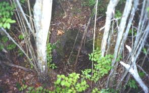
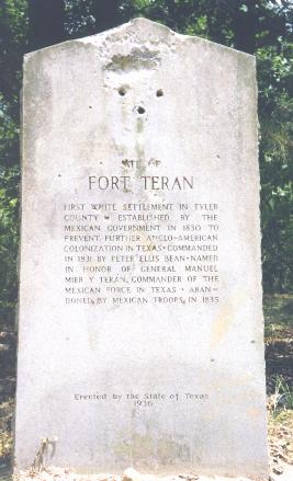
Don explained to us the controversy and two theories of where precisely the fort was constructed. One theory holds that it was precisely on the river not far up the trail where the ferry landed which would make a direct and strategic position for monitoring traffic off the ferry. Another theory contends that the fort was constructed some distance from the crossing up the Neches River on a hill overlooking it which was some distance from the actual traffic, but in a more strategic position for monitoring the entire countryside. It turns out the question is not at all settled. The State of Texas historical marker was at first placed at the lower river crossing site and later moved up on the ridge to the latter site. Don showed us what is believed to be fairly precisely the exact river crossing site and the old homeplace and general store of Samuel T. Belt described in the Handbook of Texas extract below. A filled in well was easily discernable at the site. Don informed us that various artifacts from the period continue to surface after hard rains although the site has historically been finely combed by visitors and pothunters over the years. One could envision the quiet camps of families holding their "empresario passports" on both sides of the river with optimistic conversations of the hope and opportunity of the new land, of how it would be to be citizens of Mexico, and of course the rumors of despots in far away Saltillo and Mexico City who were intent on reversing the hard won successes of the "George Washingtons" of Mexico, names like Hidalgo, Morelos, Guerrero, and their own Anglo-Mexican empresarios Austin and DeWitt. Interspersed with the families with dreams were the new breed of adventurers and "filibusters" boasting that Texas was theirs by some sort of racial divine right passed on by their ancestors and earned by their successful rebellion against their own race in the United States of the North. At the center of the action was Tennessee-Mexican Colonel Pedro (Peter) Ellis Bean, probably the one single individual who by sheer experience understood best the diversity of forces converging to drive events at the site. Captured by the Spanish in New Spanish Texas in his twenties with filibuster Phillip Nolan, Bean spent numerous years in and out of Spanish prisons until both royalist and insurgent forces realized the value of his knowledge, all self-taught, of explosives and munitions. A confidant of Jose Morelos, Bean commanded the Mexican insurgent troops who took Acapulco. In contrast to both insurgent and royal commanders, Bean was respected by both sides for his humane treatment of prisoners. He was a Morelos emissary to the United States during which he met the Barratarians LaFitte and You in New Orleans and served with them in the Battle of New Orleans. Bean was equally comfortable among the indigenous Indian populations, Anglo and Hispanic societies throughout the Americas. His personal relationships, although sometimes stormy, included families in Tennessee and Texas as well as southern Mexico where the loyal and relatively well to do Doña Magdalena Falfan de los Godos waited patiently at the Hacienda Banderilla near Jalapa. Bean returned there in 1843 where he spent the last three years of his life. Bean's lawyer was Thomas Jefferson Rusk and he was a close personal friend of General Sam Houston. Col. Bean and his men were charged with building, supplying and maintaining Ft. Teran and executing diplomatically the orders of commandante Manuel Mier y Terán.
For additional Texian Web Site Visits see:
From the New Handbook of Texas The site was in what is now Tyler County about a half mile downstream from the mouth of Shawnee Creek and three miles west of Rockland. The crossing at this point provided access to a feasible route across the Kisatchie Wold, a ridge that extends from the Mississippi River to the lower Rio Grande valley of Texas and that was a formidable obstacle for north-south travel. In northern Tyler County this ridge reaches heights of 400 to 450 feet above sea level at several of its peaks and has forced the Neches River to run eastward along the northern boundary of Tyler County. Construction of a fort on the Neches River was a result of General Terán's inspection tour of East Texas in 1829. He observed that immigrants and smugglers were coming into Texas from Louisiana by using unguarded trails such as the Coushatta Trace, the Alabama Trace, and the Nacogdoches-Orcoquisac Road, all of which crossed the Neches River at the future site of Fort Teran. When Terán returned to Mexico, he helped to draft Anastasio Bustamante's Law of April 6, 1830, forbidding American immigrants to settle in Mexican territory. Responsibility for enforcing this law was assigned to a "director of colonization," and Terán was the first to hold this office. His program for closing Texas to immigrants from the United States included establishing garrisons on the Neches and several other rivers. He chose Peter Ellis Bean, a colonel in the Mexican army, to construct Fort Teran on the Neches. On September 25, 1831, Bean departed from Nacogdoches to establish the fort. Apparently construction proceeded very slowly, since the military commandant at Nacogdoches, José de las Piedras, on April 19, 1832, reported the need for additional carpenters and other craftsmen to assist in building the fort. When completed, this project consisted of approximately ten wooden cabins to provide housing for Colonel Bean and his small garrison. The Mexican government, however, found itself unable to support its Texas forts adequately, and later in 1832 transferred most of the troops. After Fort Teran was abandoned by the remaining troops in 1834, the population in the immediate area was about a dozen persons. Samuel T. Belt opened a trading post at the fort site. A post office operated there in 1856-66, and this small community, sometimes called Fort Turan, continued as a trading and shipping point until the railroads came to Tyler and Angelina counties in the 1880s. Until 1878 steamboats continued to land near the fort, which was at the head of navigation on the Neches River. When Texas counties were organized after 1845, Fort Teran was used as a point of reference in describing the boundaries of Angelina and Jasper counties. Another of Belt's enterprises was the operation of a ferry at the Fort Teran crossing. Stagecoaches used this crossing for many years. The ferry operated first as Belt's Ferry, then Boone's Ferry and Duncan Ferry, until the completion of a state highway through Rockland in 1917. BIBLIOGRAPHY: Juan N. Almonte, "Statistical Report of Texas," Southwestern Historical Quarterly 28 (January 1925). Wallace W. Atwood, The Physiographic Provinces of North America (Boston: Ginn, 1940). Eugene C. Barker, Readings in Texas History (Dallas: Southwest Press, 1929). David J. Weber, The Mexican Frontier, 1821-1846 (Albuquerque: University of New Mexico Press, 1982). James E. Wheat, "The Story of Fort Teran on the Neches," It's Dogwood Time in Tyler County, March 1951. James E. and Josiah Wheat, "Tyler County under Mexico," It's Dogwood Time in Tyler County, March 1966. Amelia W. Williams and Eugene C. Barker, eds., The Writings of Sam Houston, 1813-1863 (8 vols., Austin: University of Texas Press, 1938-43; rpt., Austin and New York: Pemberton Press, 1970). Howard N. Martin Don C. Marler (1933-2016) was an author and owner of Dogwood Press, a publisher and distributor of books about West Louisiana, East Texas and Jean LaFitte. He was an expert on the history of the mystery cultures of the Melungeons of the southeastern USA and the Louisiana Redbones (his book is Redbones of Louisiana by Don C. Marler). For a hobby, he raised Peruvian Paso ponies imported from South America that he contends are the precursors to the Texas Mustang left by the Spanish in their numerous entradas. He also raised the pure breed of work dogs called Catahoula Cur or Hog Dogs (also called Blue Leopards in Texas) that are believed to have been the favorite of the Spanish in Louisiana and Texas which aided in herding their longhorn, goats and hogs in and prior to the 18th century. Sons of DeWitt Colony continues his interest in any information on Ft. Teran and Colonel Peter Ellis Bean, its builder and commander that would contain clues to archival floor plans, building instructions, rosters and precise locations of sites in the area. SONS OF DEWITT
COLONY TEXAS |
 Ft.
Teran Site Visit July 1998
Ft.
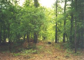
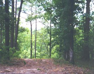
Teran Site Visit July 1998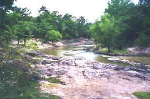 (One putative site of Ft. Teran and the 3-trace Neches River crossing.
Normally the river would be up to the green line on the left and in the trees on the
right) Trekking around mostly looking at the ground for pottery shreds and old bottle
parts in the steamy east Texas woods in mid-summer reminded us what a place the area was
before modern conveniences and air conditioning. In view of the current level of the
Neches River at the crossing where three major trails coming into Mexican Texas from the
east, it was hard to believe that flat bottom steamboats actually navigated the river and
a ferry for wagons, horses and oxcarts was needed to traverse it. Don informed us that
this was the lowest level that he had seen the river in his 15 years in the area and that
in fact on average the river was probably quite a waterway and obstacle, sometimes raging
over its banks, in the days before dams and modern developments. He pointed out what
better location could one have for a store in the wilderness than that of Samuel Belt
whose clients were willing to pay quite a price for basics after having spent several days
camped on either side of the crossing, particularly when the crossing took several days
waiting for the river to calm down.
(One putative site of Ft. Teran and the 3-trace Neches River crossing.
Normally the river would be up to the green line on the left and in the trees on the
right) Trekking around mostly looking at the ground for pottery shreds and old bottle
parts in the steamy east Texas woods in mid-summer reminded us what a place the area was
before modern conveniences and air conditioning. In view of the current level of the
Neches River at the crossing where three major trails coming into Mexican Texas from the
east, it was hard to believe that flat bottom steamboats actually navigated the river and
a ferry for wagons, horses and oxcarts was needed to traverse it. Don informed us that
this was the lowest level that he had seen the river in his 15 years in the area and that
in fact on average the river was probably quite a waterway and obstacle, sometimes raging
over its banks, in the days before dams and modern developments. He pointed out what
better location could one have for a store in the wilderness than that of Samuel Belt
whose clients were willing to pay quite a price for basics after having spent several days
camped on either side of the crossing, particularly when the crossing took several days
waiting for the river to calm down.